J Lilly; G Capodaglio; D Engwirda; R Higdon; M Petersen
Journal of Computational Physics, 520
D Xu; G Bisht; D Feng; Z Tan; L Li; H Qiu; R Leung
Earth's Future, 12
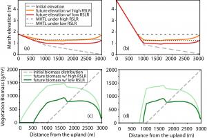
Z Tan; R Leung; C Liao; L Carniello; J Rodríguez; P Saco; S Sandi
Frontiers in Earth Science, 12
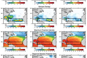
E John; K Balaguru; R Leung; S Hagos; R Hetland
Geophysical Research Letters, 51
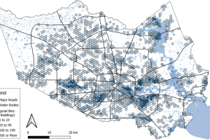
M Deb; J Benedict; N Sun; Z Yang; R Hetland; D Judi; T Wang
Natural Hazards and Earth System Sciences 24(7)
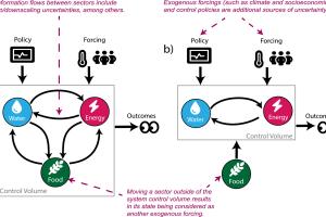
G Abeshu; H Li; M Shi; J Brookshire; J Tang; C Xu; N McDowell; L Leung
Journal of Hydrologic Engineering 29(5)
D Feng; Z Tan; D Engwirda; J Wolfe; D Xu; C Liao; G Bisht; J Benedict; T Zhou; H Li; R Leung
Journal of Advances in Modeling Earth 16
K Balaguru; C Chang; R Leung; G Foltz; S Hagos; M Wehner; J Kossin; M Ting; W Xu
Earth's Future 12
L Li; G Bisht; D Hao; R Leung
Earth System Science Data (16)
N Sun; M Wigmosta; H Yan; H Eldardiry; Z Yang; M Deb; T Wang; D Judi
Earth's Future 12(3)
D Xu; G Bisht; Z Tan; E Sinha; A Di Vittorio; T Zhou; V Ivanov; L Leung
Nature Communications 15(1)
D Xu; G Bisht; Z Tan; C Liao; T Zhou; H Li; L Leung
Geosci. Model Dev. 17(3)
W Xu; K Balaguru; D Judi; J Rice; L Leung; S Lipari
Scientific Data 11(1)
P St‐Laurent; M Friedrichs
Journal Of Advances In Modeling Earth Systems 16(1)
J Lilly; D Engwirda; G Capodaglio; R Higdon; M Petersen
Mon. Wea. Rev. 151
S Chand; K Walsh; S Camargo; J Kossin; K Tory; M Wehner; J Chan; P Klotzbach; A Dowdy; S Bell; H Ramsay; H Murakami
Nat. Clim. Chang. 14
C Liao; M Cooper
Journal of Open Source Software 8(91)
D Feng; Z Tan; D Xu; R Leung
Hydrol. Earth Syst. Sci. 27(21)
C Liao; T Zhou; D Xu; Z Tan; G Bisht; M Cooper; D Engwirda; H Li; R Leung
Journal of Advances in Modeling Earth Systems 15(11)
C Lee; A Sobel; M Tippett; S Camargo; M Wüest; M Wehner; H Murakami
Earth's Future 11(11)
D Hao; G Bisht; H Wang; D Xu; H Huang; Y Qian; L Leung
Nature Communications 14(1)
A Narayanan; K Balaguru; W Xu; L Leung
Nat Hazards 120
X Li; T Chakraborty; G Wang
Urban Climate 51
E Mazza; S Chen
Journal Of Hydrometeorology 24(9)
N Da; G Foltz; K Balaguru; E Fernald
Journal of Climate 36
M Gore; C Zarzycki; M Gervais
Earth's Future 11(8)
E John; K Balaguru; L Leung; G Foltz; R Hetland; S Hagos
Weather And Forecasting 38(8)
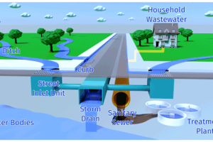
J Yoon; H Wan; B Daniel; V Srikrishnan; D Judi
Computers, Environment and Urban Systems 103
E Mazza; S Chen
Journal Of Geophysical Research: Atmospheres 128(13)
TC Chakraborty; A Newman; Y Qian; A Hsu; G Sheriff
One Earth 6(6)
Z Xue; P Ullrich; R Leung
Hydrol. Earth Syst. Sci. 27(9)
B Kerns; S Chen
Wea. Forecasting 38
D Schlichting; L Qu; D Kobashi; R Hetland
Journal of Advances in Modeling Earth Systems
K Balaguru; W Xu; C Chang; R Leung; D Judi; S Hagos; M Wehner; J Kossin; M Ting
Science Advances 9(14)
W Liu; P Ullrich; J Li; C Zarzycki; P Caldwell; L Leung; Y Qian
Journal Of Advances In Modeling Earth Systems 15(4)
D Mithun; N Sun; Z Yang; T Wang; D Judi; Z Xiao; M Wigmosta
Earth's Future 11(3)
N Pal; K Barton; M Petersen; S Brus; D Engwirda; B Arbic; A Roberts; J Westerink; D Wirasaet
Geosci. Model Dev. 16
D Feng; Z Tan; Q He
Water Resources Research 59
B Pokharel; S Sharma; J Stuivenvolt-Allen; S Wang; M LaPlante; R Gillies; S Khanal
Climatic Change 176(2)
C Liao; T Zhou; D Xu; M Cooper; D Engwirda; H Li; R Leung
Journal of Advances in Modeling Earth Systems 15(2)
W B Daniel; C Roth; C Rakowski; T McPherson; D Judi
Environmental Modelling & Software 161
J Lilly; G Capodaglio; M Petersen; S Brus; D Engwirda; R Higdon
Journal of Advances in Modeling Earth Systems 15(1)
J Li; Y Qian; R Leung; X Chen; Z Yang; Z Feng
JGR Atmospheres 128(2)
S Brus; K Barton; N Pal; A Roberts; D Engwirda; M Petersen; B Arbic; D Wirasaet; J Westerink; M Schindelegger
Ocean Modelling 182
C Tebaldi
Climate Risk Management 40
J Stachelek; A Sofia; S Jon
Journal Of Applied Remote Sensing 16(04)
R Hetland
The Mathematics of Marine Modelling: Water, Solute and Particle Dynamics in Estuaries and Shallow Seas (197-211)
B Kerns; S Chen
Nat Hazards 116
Z Xue; P Ullrich
Journal of Climate
D Feng; Z Tan; D Engwirda; C Liao; D Xu; G Bisht; T Zhou; H Li; R Leung
Hydrol. Earth Syst. Sci. 26
L Dong; R Leung
Journal of Geophysical Research 127(22)
H Wan; J Yoon; V Srikrishnan; B Daniel; D Judi
Computers, Environment and Urban Systems 99
L Qu; T Leif; H Robert; K Daijiro
J. Phys. Oceanogr. 52(11)
C Cooper; S Sharma; R Nicholas; K Keller
Earth's Future 10(11)
L Qu; R Hetland; D Schlichting
Journal of Physical Oceanography 52(11)
K Balaguru; G Foltz; R Leung; W Xu
Geophys. Res. Lett. 49
K Barton; N Pal; S Brus; M Petersen; B Arbic; D Engwirda; A Roberts; J Westerink; D Wirasaet; M Schindelegger
Journal of Advances in Modeling Earth Systems 14(11)
Y Feng; J Huang; Y Dan; K Balaguru; W Ma; Q Feng; X Wan; Y Zheng; X Guo; S Cai
JGR Biogeosciences 127(10)
L Qu
Nature Communications 13(1)
J Huff; R Kevin; B Julio; W Michael
Climate 10(9)
K Smiley; I Noy; M Wehner; D Frame; C Sampson; O Wing
Nature Communications 13(1)
T Chegini; H Li
Hydrology and Earth System Sciences 26(16)
V Srikrishnan; D Lafferty; T Wong; J Lamontagne; J Quinn; S Sharma; N Molla; J Herman; R Sriver; J Morris; B Lee
Earth's Future 10(8)
D Xu; G Bisht; T Zhou; R Leung
Journal of Advances in Modeling Earth Systems
L Li; G Bisht; R Leung
Geosci. Model Dev. 15
D Xu; G Bisht; L Chang; R Leung
Geosci. Model Dev. 15
S Chand; W Kevin; C Suzana; K James; T Kevin; W Michael; C Johnny
Nature Climate Change 12(7)
Y Zhang; D Svyatsky; J Rowland; D Moulton; Z Cao; P Wolfram; C Xu; D Pasqualini
Water Resources Research 58
K Balaguru; G Foltz; R Leung; S Hagos
Geophys. Res. Lett. 49
R Sukhdeo; P Ullrich; R Grotjahn
Climate Dynamics
J Li; Y Qian; R Leung; Z Feng; C Sarangi; Y Liu; Z Yang
Geophys. Res. Lett. 49
K Reed; M Wehner; C Zarzycki
Nature Communications 13(1)
R West; H Lopez; S Lee; A Mercer; D Kim; G Foltz; K Balaguru
Geophysical Research Letters 49(4)
M Wehner; K Reed
PLOS Clim 1(2)
Y Qian; TC Chakraborty; J Li; D Li; C He; C Sarangi; F Chen; X Yang; R Leung
Advances in Atmospheric Sciences 39(6)
G Capodaglio; M Petersen
Journal of Computational Physics 449
T Chegini; G Coelho; J Ratcliff; C Ferreira; K Mandli; P Burke; H Li
Jawra Journal Of The American Water Resources Association 58(1)
C Liao; T Zhou; D Xu; R Barnes; G Bisht; H Li; Z Tan; T Tesfa; Z Duan; D Engwirda; R Leung
Advances in Water Resources 160
M Wehner
UNESCO Mathematics for Action Report pp37-38
C Sarangi; Y Qian; J Li; R Leung; T Chakraborty; Y Liu
Geophysical Research Letters, 48
N Sun; M Wigmosta; D Judi; Z Yang; Z Xiao; T Wang
Environmental Research Letters 16
H Wan; J Yoon; V Srikrishnan; B Daniel; D Judi
Cartography and Geographic Information Science 49
T Chegini; H Li; R Leung
Journal Of Open Source Software 6(66)
C Tebaldi; R Ranasinghe; M Vousdoukas; D Rasmussen; B Vega-Westhoff; E Kirezci; R Kopp; R Sriver; L Metaschi
Nature Climate Change 11
Z Xue; P Ullrich
J. Hydrometeorology 22(9)
Z Xiao; Z Yang; T Wang; N Sun; M Wigmosta; D Judi
Frontiers in Marine Science 8
W Xu; K Balaguru; A August; N Lalo; N Hodas; M DeMaria; D Judi
Weather and Forecasting 36(4)
J Li; Y Qian; L Leung; Z Feng
J. Geophys. Res. Atmos. 126
Z Xue; P Ullrich
Earth's Future 9(7)
Q Li; J Bruggeman; H Burchard; K Klingbeil; L Umlauf; K Bolding
Geoscientific Model Development 14(7)
M Wehner; C Sampson
Climatic Change 166
J Li; Z Feng; Y Qian; L Leung
Earth System Science Data 13
D Pasqualini; J Rowland
US CLIVAR Variations Fall 2020 18(3)
S Mondal; A Mishra; R Leung
Geophysical Research Letters 47(15)