Overview
The mid-Atlantic region features densely populated urban centers, expensive real estate, a diverse range of economic activities, and a wide range of critical infrastructure (stormwater, wastewater, transportation, electricity, etc.). Natural system features in coastal zones create amenities that are a primary driver of coastal development (river and beachfront property, recreational opportunities, ports, etc.). Unfortunately, coastal areas are also subject to a wide range of natural and human system hazards, including acute events, such as extreme flooding, and long-term changes, such as sea level rise, saltwater intrusion, and aging infrastructure. Human activities in coastal regions can exacerbate these hazards due to urbanization (e.g., development in floodplains and increases in impervious surfaces) or poor infrastructure management and flood mitigation practices. On the other hand, environmental, institutional, and economic factors may influence human systems to adapt over time, thereby reducing risks.
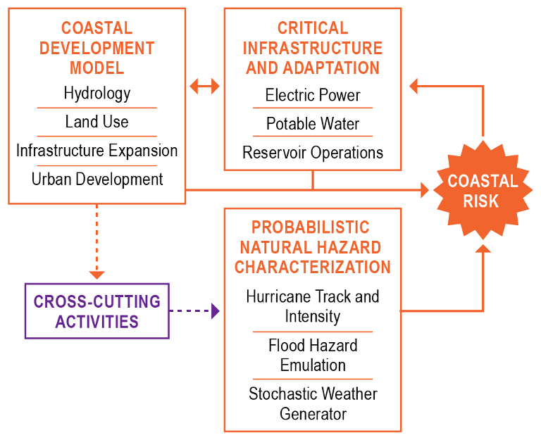
The MultiSector Dynamics (MSD) program area in ICoM focuses on coupling infrastructure, coastal development, and hazard modeling and emulation to characterize the time-evolving risks and resilience of coastal systems. Ultimately, these components will be integrated into a comprehensive research framework to investigate co-evolving changes in risk and are anticipated to help investigate three primary science questions:
- How might time-evolving stressors in the natural system affect risks to human systems in coastal regions?
- How might coastal development patterns and critical infrastructure management influence flooding and drought risks in coastal regions?
- How can adaptation strategies influence coevolving human and natural systems in coastal regions to reduce risk or enhance resilience?
Probabilistic Characterization of Natural Hazards
Assessing the risk associated with flooding and other hazards in coastal regions requires a robust characterization of the hazards, including associated uncertainties. Inability to characterize distribution tails, either through inadequate process representation or limited sample size, can have cascading influences in the risk-paradigm, including risk-based adaptation decisions. To accurately characterize these risks, we are leveraging a limited set of high-resolution, physics-based hazard simulations to drive a series of individual simulations of flood and drought impacts on coastal development and infrastructure systems. However, computational requirements associated with the high-resolution hydrology models limit the number of case studies that we can examine.
To more fully characterize flood and drought hazards in the mid-Atlantic region, especially the tails of the hazard probability distributions, we will develop large ensembles of hazard realizations using several approaches, including emulation, a statistical–dynamical hurricane track and intensity model, and a stochastic weather generator.
Integrated Coastal Development Model
Development patterns have a major influence on the exposure and vulnerability of human systems to flooding and other natural system stressors and therefore on private and public economic costs. Previous ABM efforts have aspired towards this level of integration, they have been limited to: (1) domain- or discipline-centric case studies in which one or more key physical processes (e.g., flooding impact) or critical human decision spaces (e.g., land use policy or infrastructure development) are handled exogenously, meaning that how these factors might dynamically coevolve with other subsystem components is ignored, or (2) methodological proof-of-concepts that focus on highly stylized or hypothetical use cases.
In this task, we are developing a coupled human-natural system model by integrating hydrologic modeling of water availability and flooding with an agent-based model (ABM) that accounts for economic, land use, and critical infrastructure expansion decisions. The development of such a model integrates the key physical, demographic, economic, and institutional drivers of coastal development for real-world coastal systems
will be a transformational step in our scientific understanding and representation of coastal system
dynamics.
Critical Infrastructure Modeling
Human-engineered systems, such as electrical or water networks, respond in complex ways to natural hazards. For example, the effects of flood damage to individual system components such as generators, substations, or pumping stations may cascade to network-wide system failures, including cross-sectoral effects such as the loss of electrical power for water pumping stations. Existing approaches rarely consider cascading network effects, particularly with the physical fidelity needed to represent the system dynamics that drive realistic system failure modes, such as the inability to rebalance electrical load after damage during storm events. Moreover, few studies have examined the risk of these cascading failures in the context of a broad range of plausible natural hazard scenarios, which is essential for evaluating risk.
We are leveraging existing models used in the context of other infrastructure resilience programs to simulate the impacts of flood and drought events on electric power and water networks in the mid-Atlantic region at high spatiotemporal and process resolution. These high-fidelity, physics-based models are being adapted to understand long-term trends and behaviors in interconnected infrastructure systems, including unique approaches to consider infrastructure adaptation endogenously in infrastructure models.